Wednesday 19 December 2012

Plosky Tolbachik volcano Erupts


Since November a volcano has been erupting in the Kamchatka Peninsula.
If Landscape is what happens when environment is perceived by people -- the wider dissemination of this news is turning a natural event into landscape as we speak


View Larger Map

A saunter around Clarinbridge, in Ireland


Just a wander around Clarinbridge -- Just one thing to point out. At the last picture there is a view into the Burren and on top of the hill, you can just see a cairn. Cairns, tombs etc. on the north side of the Burren overlook Galway Bay, whereaas there are no such sited cairns and tombs on the Atlantic Coast (I found out when doing the Clare Historic Landscape Characterisation. see http://www.heritagecouncil.ie/fileadmin/user_upload/Publications/Landscape/Landscape_Clare/area_1.pdf
 in http://www.heritagecouncil.ie/landscape/publications/landscape-character-assessment-of-co-clare/

Created with Admarket's flickrSLiDR.

View Larger Map

Daily life in Medieval Sherwood Forest- Peasant Rights

Reproduced from http://sherwoodforesthistory.blogspot.co.uk/ - an excellent blog and well worth a browse. Much of this applies also to Epping and Hatfield Forests, which extend into Greater London. Epping Forest was preserved for the public by the Corporation of London as a result of popular resistance in favour of the Commoners Right of Lopping, that is to take lower branches from trees as firewood http://www.hillsamenitysociety.co.uk/detail/efbattle.htm

Daily life in Medieval Sherwood Forest- Peasant Rights


Medieval society and the medieval landscape were for the common person predominantly rural and agricultural in nature.

Very little of the landscape was not utilised, and in some areas such as the ‘Champion’ (from the French champ- for field) landscapes of the Midlands, almost every inch was turned over to arable- especially in the boom years of population expanse during the 13th century.

In Sherwood Forest it was similar, in that almost every resource was used.


Every village had its great open fields, where crops were rotated through the season, and the people farmed strips of land spread throughout them. Each year one field stood fallow to recover for the following years crops.

This fallow field was fertilized by the animals of the village. Pigs and sheep would be concentrated at night into temporary pens to ‘focus’ their fertilization efforts.

Between these times it was necessary to graze animals away from the open fields.

No matter how much an animal fertilizes a field it will always take more nutrients than it returns, if it grazes exclusively from the same field that it fertilizes, as it requires nutrients to grow.

An external source of nutrients and energy was therefore required, and in Sherwood Forest this came from the great heaths and Lyngges ( Old Scandinavian for heather- see There’s Vikings in the Heather entry).

Shepherds and swineherds would tend their flocks and herds on these vast swathes of lowland heath around Sherwood Forest that stretched for mile after mile across the open countryside. Vast areas such as ‘Basforde Lyngges’, the heaths of Rufford Abbey Lordship, ‘Budby Oute Fieldes’ and the ‘Moor of Kirby’, would be dotted with these herds, and the sight of flocks and shepherds would have been common to the traveller passing through the forest.

Each parish had their own areas of woodland, usually at their edges.

In the more populated southern ‘Thorneywood’ area they occupied the high ground between parishes, such as on the ridges between the villages of Lambley, Woodborough and Calverton.

These woods often joined together to form giant woods that could cover miles, but they each had names reflecting to whom they belonged. Carleton Wode, Gedling Wode, Basforde Wode (named after villages) Kettulbarne Haw, Fox Swaht, Prior Stobyn, Samson Wode (after landscape features or owners past and present).

In the ‘High Forest’, (the northern part of Sherwood Forest) these woods were sometimes vast such as the great Maunsfelde (Mansfield) Wode, Sutton Wode, Blidworth Wood and Hay Wode, as well as the great crown woods of the Hay of Birklands, Bilhaugh and Lyndhurst Wood (see Lyndhurst Wood- the chief wood of Sherwood entry).

It is worth reminding that nobody could actually cut down the tress in these woods for timber because it was forbidden by Forest Law (see Forest Law page). However the rights to the woods were heavily guarded by the people, because they had other kinds of rights within them.

As well as the rights to pasture on the great heaths and commons peasants had the right to graze their animals in woodland at certain times of the year. One such time was the ‘Pannage’ season (just after the acorns fell) when peasant could graze their pigs on acorns in the woods of the forest.

Picutre: A peasant beating acorns from the tree for his pigs

These rights to access woods were strictly controlled under Forest Law with ‘Agisters’ acting as tax collectors to control quotas and extract fines (see Forest Law Page)

Peasants also had the right to take some smaller timber from the woods for ‘Haybote’ (hedge repair) and ‘Husbote’ (house repair).

These rights were often jealously guarded!

An Inquisition Post Mortem into the rights of the people of Clipstone Manor, dated20th April 1327 early in the reign of Edward III shows some of the rights of the peasant to the resources of their land.

The Inquisition was presented in front of John De Crombwell Keeper of the Kings Forest beyond Trent, by the oath of John de Annesley; Philip de Caltoft, knight; Thomas Whaton; Richard Russell; Richard Ingam; John de Holm; Richard de Bestewod (Bestwood); Thomas de Lyndeby; Simon de Lameley; John le Warde of Crathethopre; William Basage; and john Moigne of Carleton…

‘The King’s tenants of his manor of Clypston in Shirwod (Sherwood), which is of ancient demesne of the crown of England, and their ancestors, tenants of the same manor, from time immemorial have been accustomed to have all ferns growing in a place which is now called the park of Clypston, for thirteen shillings and six pence, to be rendered yearly to the King’s ancestors by the hands of the justice of the Forest; and to collect the leaves fallen from the trees in the same place for manuring their lands, without rendering anything therefor; and to have pasture for all kinds of beasts in the same, doing in return the custody of the vert and venison in the same place by two of the tenants’.

This shows how the peasants had customary rights to access the ‘park’ for livestock grazing, and to gather ferns and leaves for fertilizer, (in exchange for looking after the deer and timber for the King)

It also shows that they were empowered enough to appeal through the court system to protect those rights.

The reason for the inquest is that Edward II had closed off access to the park, preventing them from their customary rights. The newly crowned Edward III was being petitioned by the men of Clipstone to have their rights returned. They also informed the King that he was losing the money they would normally pay for their rights!!!

Presumably he would be more likely to listen if his wallet was affected.

The men also pointed out that they could not get sufficient pasture outside of the park for their needs- as stated earlier nutrients for flocks and open fields needed to come from somewhere other than the fields themselves.

So as can be seen the landscape of Sherwood Forest provided opportunities for people to make their living from agriculture and from accessing the resources that the Forest provided around them. It was also the case that people would guard these rights vigorously, petitioning through the courts and to the legal system.

The laws of the land prevented many people from having many things, but they also enshrined rights over generations and the law could be called upon to protect those rights if they were threatened.

(More on farming practices in Medieval Sherwood Forest including the ‘Breck System’, and more on the courts and laws of everyday medieval life coming soon).

London walking tours to sites of agitation and protest.

David Rosenberg http://www.eastendwalks.com/  has a walking tour course starting in April 2013. A great way to acquaint yourself with a landscape of poverty, wealth and protest.
http://www.citylit.ac.uk/courses/Humanities/London_walks/In_the_footsteps_of_London%27s_rebels
Dock Strike float (image c/o  http://www.eastendwalks.com/)


Course outline

What is the course about?
The course conveys this exciting history against the backdrop of 19th century and early 20th century London through a series of walking tours to sites of agitation and protest. These tours will include visits to buildings and institutions connected with this history.
What topics will we cover?
We will learn about inspirational individuals and movements that fought for radical change in the workplace, in their communities, and in the political sphere: from Chartists, suffragettes and striking matchgirls, to anarchists, conscientious objectors and anti-fascists. We will also find out what these social movements were demanding and where and how they campaigned to bring about changes in London.
By the end of this course you should be able to:
show you understand the challenges ordinary people faced in London during this period
identify the campaigns that sought to address these challenges
list key individuals that supported these campaigns.
What level is the course and do I need any particular skills?
There are no particular skills needed, just an interest in learning about London’s social and political history and an enthusiasm for discovering and imagining the places where this history happened. You will need to be able to undertake a walking tour of up to 2 hours at a moderate pace, with several stopping points. Some of the walking tours will include an indoor visit so the actual walking will be less than two hours in these sessions .
How will I be taught, and will there be any work outside the class?
There will be an initial lecture/workshop to set the background scene for the period we will be studying, and the places where we will be walking. This will be followed by a series of walking tours focusing on specific issues, individuals and campaigns. On each tour you will receive an information handout summarising key points. Students will be encouraged to ask questions on the walks and raise discussion points. The final session will be classroom based and will draw together the threads from the different walks to consolidate knowledge of protest movements in the capital and assess their successes and failures. No work is required outside of class although you will be directed to additional reading that you may wish to undertake.
Are there any other costs? Is there anything I need to bring?
There are no additional costs. All visits are free. You will need to wear comfortable walking shoes, appropriate clothing for the likely temperature outdoors, an umbrella for days when the weather is less predictable and a bottle of water for refreshment. You may wish to bring a pen and notebook to take your own notes.
Do I need to have an interview before I can enrol?
No.
What feedback will I get?
You will receive regular feedback from your tutor throughout the course, as and when appropriate. At the end of the course you and your tutor are asked to assess the progress you have made.
How will I be able to give my views on the course?
Please complete the evaluation form at the end of your course. These are monitored and help us to continually improve our courses.
How do I find out if I can get some support for my learning?
You may be interested in: education and careers advice; financial and childcare support; disability support; support for Deaf and hearing-impaired students; dyslexia support; English and maths support; counselling, and library services (supported learning centre). To find out what may be available to you, and how to apply, see page 254 of the 12/13 course guide, or visit www.citylit.ac.uk/students
When I've finished, what course can I do next?
General information and advice on courses at City Lit is available from the Information and Advice Shop, open Monday to Friday 12:00 – 19:00 during term time, and Monday to Friday 12:00 – 17:00 out of term time. See the course guide for term dates and further details.
Who can I contact for further information?
Tel: 020 7492 2652


Key course information

Dates  09/04/13 - 04/06/13
Day(s)  Tue
Duration  9 weeks
Time  15:00 - 17:00
Fees ?
Full fee: £96
Senior fee: £58
Concession: £30
Venue   KS - Keeley Street
» View location


Enrol now

Enrol now
Call enrolments: 020 7831 7831
Download form and post Still got questions?

humanities@citylit.ac.uk or call 020 7492 2652 

Wednesday 12 December 2012

Coal mining by Mountaintop Removal

We are now remodelling the earth's surface in a way that was never possible before....
Read all about it at
http://en.wikipedia.org/wiki/Mountaintop_removal_mining
see it for yourself

The All London Green Grid is launched!


On 10th December 2012,  the All London Green Grid (ALGG) was launched, with publication of the 11 Area Frameworks and the announcement of the Big Green Fund.
The aim of the All London Green Grid is to deliver a broad and deep green infrastructure across London, improving and linking the existing network of green spaces.
The Grid should help to bring about major enhancements for the capital’s wildlife habitats, and help more people to get to know enjoy their benefits.
The ALGG also presents a key opportunity for securing tangible benefits for species dependent on landscape-scale enhancements, such as water vole, bats, fish and butterflies


The All London Green Grid (ALGG) is the green infrastructure strategy for London. It  sets out a vision for the existing networks of green and blue spaces across London, and opportunities to enhance this though a series of projects across a number of area frameworks.  It identifies a wide range of functions that can be delivered by a healthy natural environment, ranging from: ‘adapting to climate change’ and ‘promoting healthy living’ to ‘conserving biodiversity and increasing access to nature’ and ‘enhancing heritage features, geodiversity and landscape character’.

A green infrastructure strategy
The ALGG stems from the earlier East London Green Grid, and is built around four key elements. London’s existing river and other key landscape corridors, including the Thames; established open spaces and identified opportunities for creating new parks, such as the Wandle Valley Regional Park; existing and proposed green connections and corridors, such as the proposed London Riverside Link; and, the designated and protected landscapes that are generally located at the boundary of London and flow across administrative boundaries to neighbouring areas and often include areas of degraded urban fringe.

The ALGG aims to promote a shift from ‘grey to green’ infrastructure in order to secure environmental, social and economic benefits. It progresses a common perception of London as a city punctuated by parks, green spaces and surrounded by countryside, to an appreciation of this network as part of the city’s fundamental infrastructure. This connected network will improve the function, use and performance of our current green infrastructure.  By being connected, the value and function of the ALGG is significantly enhanced so that it can be used in many different ways including by pedestrians, for water management, for cooling the grey urban spaces and as an ecological corridor.
A series of projects that will deliver the ALGG are set out in 11 Area Frameworks, which are due to be formally launched in July 2012. These are:
1   Lee Valley and Finchley Ridge
2   Epping Forest and Roding Valley
3   Thames Chase, Beam and Ingrebourne
5   River Cray and Southern Marshes
6   South East London Green Chain Plus
7   London’s Downlands
8   Wandle Valley
9   Arcadian Thames
10 River Colne and Crane
11 Brent Valley and Barnet Plateau
12 Central London

To support the delivery of these outcomes the All London Green Grid Supplementary Planning Guidance (SPG)  provides guidance on the implementation of London Plan policy to:


Links to the London Plan
·         Protect, conserve and enhance London’s strategic network of green and open natural and cultural spaces, to connect the everyday life of the city to a range of experiences and landscapes, town centres, public transport nodes, the countryside in the urban fringe, the Thames and major employment and residential areas;
·         Encourage greater use of, and engagement with, London’s green infrastructure; popularising key destinations within the network and fostering a greater appreciation of London’s natural and cultural landscapes; enhancing visitor facilities and extending and upgrading the walking and cycling networks in between to promote a sense of place and ownership for all who work in, visit and live in London;
·         Secure a network of high quality, well designed and multifunctional green and open spaces to establish a crucial component of urban infrastructure able to address the environmental challenges of the 21st century – most notably climate change.
This aims are in line with the emerging green infrastructure approach to the design, planning and management of landscape resources developing rapidly in Britain, Europe and North America. The objective of this approach is to plan and manage networks of natural and cultural landscapes and open spaces strategically so as to conserve ecosystem functions and provide a range of benefits for people.
The ALGG provides a framework that can connect with other Mayoral and regional initiatives and strategies, including the Climate Change Adaptation Strategy, and the London Tree & Woodland Framework.
The ALGG SPG provides guidance on the implementation of all the policy framework set out in the London Plan and is the green infrastructure strategy for London. It will be a key document for delivering improvements to the green infrastructure network and to facilitate the identification and delivery of programmes and projects promoted by the boroughs and their partners. The approach can also provide an opportunity to identify and develop green space jobs and skills training for Londoners via volunteering programmes and increasing the demand for skilled green space workers. It will also help encourage local communities to become engaged, in line with the Government’s localism agenda, by highlighting projects in which communities can become involved.
The SPG does not, however, make any specific reference to front or back gardens. This is not to deny their importance but it recognises that many of the decisions made by individual homeowners about changes to their gardens often fall outside the scope of the planning system and thus are beyond the remit of the Guidance.

See also  http://www.wildlondon.org.uk/News/the-all-london-green-grid-is-launched    (thanks to London Wildlife Trust for text above http://www.wildlondon.org.uk/all-london-green-grid  

Friday 23 November 2012

Latin American Landscape Initiative


Says...
"2.3. OBJECTIVES
The main objective of LALI is to promote the recognition, valuation, protection, planning and the sustainable management of  landscape, conducive to the declaration and recognition of the diversity and values of the diverse landscapes of our countries, by means of the fulfillment of the following specific objectives

  1. To preserve, with the adoption of protective measures of landscape, the right of the citizens to live in culturally significant surroundings and to guarantee access to the same and the possibility of enjoying it.
  2. To favor the harmonic evolution of the landscape in agreement with the concepts of rational use responsible for the land, of ecosystem functionality, and of sustainable urban development. 
  3. To consider the consequences concerning landscape, of any performance of land regulation and management, and to value the effects of the construction and other interventions (forestry, mining, new production and uses) concerning landscape. 
  4. To foment the educational formation and professionalisation on the topic of landscape. 
  5. To promote in landscape policies the participation of the social, professional, and economic agents, especially that of the professional unions, universities, associations, and representatives of the business enterprises and trade unions. 
  6. To cooperate with the diverse public administrations in the establishment of policies and implementation of planning concerning landscape. 
  7. To promote the coordination of the public and private initiatives in decision making about landscape, the adoption of instruments, and the promotion of performance on the same. 
  8. To admit that in sustainable tourism, the landscape will have to be considered as one of the components that allow cultural and economic development of diverse Latin American regions.
  9. To promote a change of attitude towards the environmental conservation and protection, as much in the inhabitants as in the visitors of each landscape, considering people as integral parts of the landscape. 
  10. To incentivise the inventory and catalogue of landscapes of ecological, historical and aesthetic value in the different Latin American regions. 
  11. To recognize the landscape units in transboundary spaces, such as shared heritage asset (binational or multinational) and to combine efforts for its integral protection, with shared responsibility. 


 FIELDS OF ACTION
Landscape, by its holistic character, integral and integrating, has impact and its time it is affected by the majority of human activities under the sky.


Monday 12 November 2012

Savage Messiah, psychogeographic London, talk by Laura Oldfield-Ford


BOOK EVENT‘Savage Messiah’ with Laura Oldfield Ford
Saturday 1st December, 6.30pm Entry £3, redeemable against purchase
Artist and writer Laura Oldfield Ford introduces her psychogeographic take on London.
Savage Messiah is an unflinching and compassionate examination of London urban landscapes within the confrontational cultural politics of the 1990’s. Originally published as a series of zines it quickly developed cult status and has recently been brought into book form by Verso. Laura will be discussing her work and the politics that permeate it. Drawing from a diverse range of fields including critical theory, illustration and an updated Punk-collage aesthetic, it considers the plight of people in areas of London facing intense structural change from the unrelenting gentrification unleashed by both Thatcherism and New Labour.

“One of the most striking fanzines of recent years is Laura Oldfield Ford’s Savage Messiah, focussing on the politics, psychology and pop- cultural past of a different London postcode. Ford’s prose is scabrous and melancholic, incorporating theoretical shards from Guy Debord and Marc Augé, and mapping the transformations to the capital that the property boom and neoliberalist economics have wrought.

Each zine is a drift, a wander through landscape that echoes certain strands of contemporary psychogeography. Ford—or a version of her, at least—is an occasional character, offering up narcotic memories of a forgotten metropolis.

The images, hand-drawn, photographed and messily laid out, suggest both outtakes from a Sophie Calle project and the dust jacket of an early 1980s anarcho-punk compilation record: that is, both poetry and protest.”—
Sukhdev Sandhu, New Statesman

Title information

Title:           Savage Messiah
Author:       Laura Oldfield Ford   
Our Price:    £19.99
Format:       Paperback
Size:           448 pages (211mm x 138mm x 31mm)
ISBN:          9781844677474
Publisher:     Verso Books
Published:    29 September 2011
smartphone or desktop calendar using Google Calendar.

Bridge over untroubled moving waters = Trim, Ireland

I was at University with an Alison Trim, named after this place in Ireland... Trim Castle in the background and a picnic party in the 19th century (thanks to the National Library of Ireland)
Bridge over untroubled water by National Library of Ireland on The Commons
Same bridge now the water has gone
View Larger Map .Same  Trim Castle now
View Larger Map
And The OS map showing where the river was in the 19th Century (follow link)
http://maps.osi.ie/publicviewer/#V1,680521,756536,7,9 

Saturday 3 November 2012

Pumpkins, Gourds, Bangladeshi-type gardens, Tree houses and urban planning in.... Denmark

Much is made of character - developments enrich or detract from it, etc. so I noticed this autumn....


Bangladeshi-type gardens at Stepney City Farm
http://www.flickr.com/photos/davidsankey/4771243493/in/set-72157624302897051
Pumpkins and gourds grown over structures are a feature of Bangladeshi-type gardens found now in the East End of London (including a tiny patch outside of my block of flats) http://www.a3associates.com/allotment_photos.html ... They have become "characteristic" of the East End

The image below shows what a magnificent display many varieties of gourds and pumpkins can make when grown together. I look forward to more of this

Talking of verticality: this  picture below is purportedly a TREE HOUSE....

The world's largest tree house is located in Crossville, Tennessee, USA.
Built by Horace Burgess, a Landscape Architect.

....and contrasts with
Urban planning in Denmark
These Circles lie just below the O3 / 21 junction below, and contrast with the high-density housing and industrial estate north of the 21. 


View Larger Map

I am much reminded of Guy Debord's map of Paris torn along the lines of Boulevards - 
Guy Debord 1957: Psychogeographic guide of Paris
and neighbourhoods, good.... and bad?

Thursday 25 October 2012

Allotment holders in Hastings, Lives in a Landscape (radio programme) and the European Landscape Convention


The landscape is part of the land, as perceived by local people or visitors, which evolves through time as a result of being acted upon by natural forces and human beings. http://www.coe.int/t/dg4/cultureheritage/heritage/Landscape/presentation_en.asp

Since the European Landscape Convention puts people at the heart of landscape policy formation, as genuine participants rather than passive consultees, it is worth listening to the BBC R4 programme Lives in a Landscape, to see how people use their landscape, and/or how the landscape helps forge them, its centrality to their lives http://www.bbc.co.uk/programmes/b006rcd7

Podcast http://www.bbc.co.uk/podcasts/series/lial
I was particularly interested by the tales of allotment holders. The rent a small piece of land from local government for a very cheap rent, to grow mainly vegetables and fruit. The community and activity of cultivation provides them with emotional support more valuable than vegetables alone

Lives: 24 Oct 12 The Allotment

Thu, 25 Oct 12
Duration:
28 mins
Alan Dein visits a Hastings allotment and finds that a plot of land means a lot more to people than a place to grow vegetables. He joins various allotmenteers as they tend their plot and hears how differently they use it. A young family have created a haven where the children learn about nature; a teacher who tended the land as a means of combatting depression and two friends meet under a full moon to await the wild original inhabitants of the allotment. Producers: Sarah Bowen and Neil McCarthy

http://downloads.bbc.co.uk/podcasts/radio4/lial/lial_20121025-1204a.mp3


The European Landscape Convention
As a reflection of European identity and diversity, the landscape is our living natural and cultural heritage, be it ordinary or outstanding, urban or rural, on land or in water.

The European Landscape Convention - also known as the Florence Convention, - promotes the protection, management and planning of European landscapes and organises European co-operation on landscape issues. The convention was adopted on 20 October 2000 in Florence (Italy) and came into force on 1 March 2004 (Council of Europe Treaty Series no. 176). It is open for signature by member states of the Council of Europe and for accession by the European Community and European non-member states. It is the first international treaty to be exclusively concerned with all dimensions of European landscape. (more...)

About the Convention


Documentation


Meetings of the Convention


Landscape Award


National actions


Hand Drawn Maps and cartography


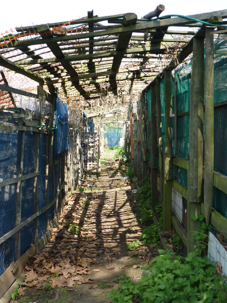
Following my earlier post on Kristiina Sandoe's map / print combining landscape memory and art....
Kristiina Sandoe's "Lizard Landscape Map" at the Natural Eye Exhibition 
http://londonlandscapeobservatory.blogspot.co.uk/2012/09/lizard-landscape-at-society-of-wildlife.html
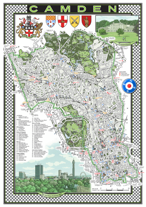
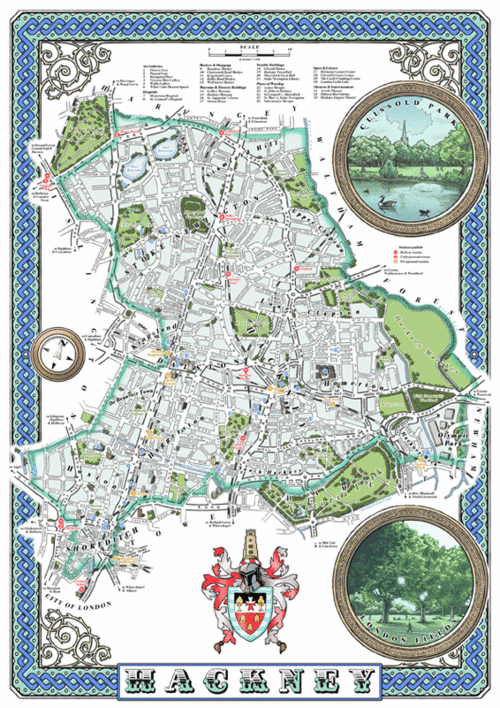
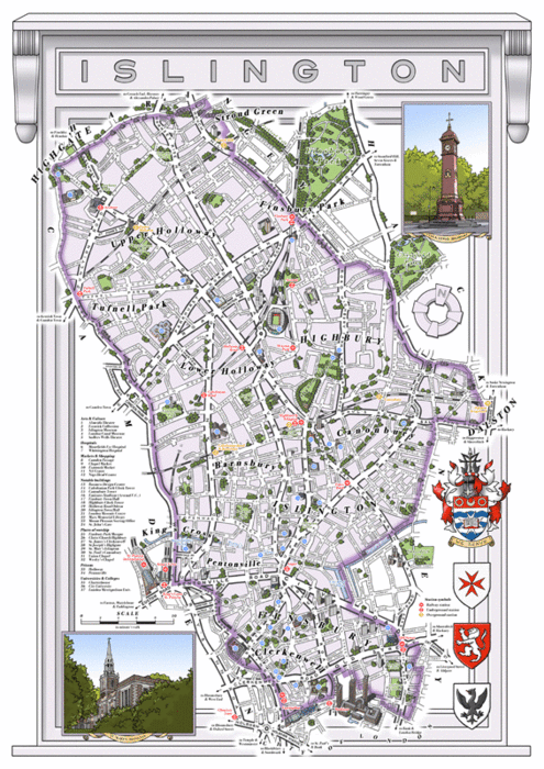
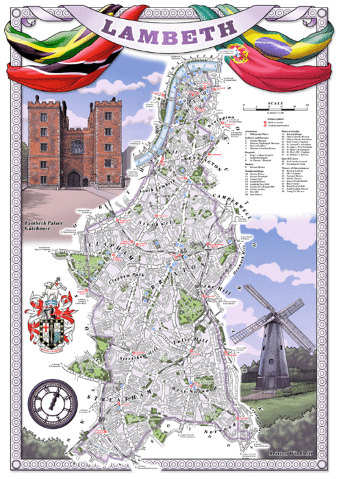
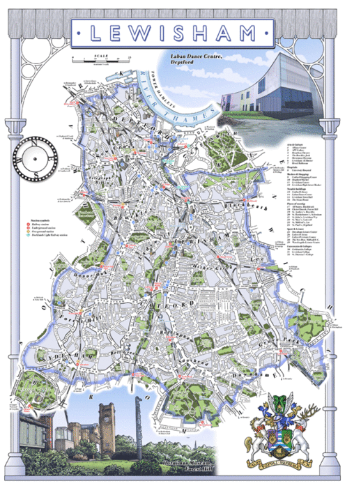
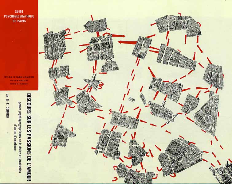
....Two more Cartographers have caught my eye. Mike Hall does excellent maps in an old tradition that incorporates pride of place within representation. In areas that require some regenereation, taking pride in an area is a crucial attribute:
http://www.thisismikehall.com/londonboroughmaps

London Borough of Camden
Royal Borough of Greenwich
London Borough of Hackney
London Borough of Islington
London Borough of Lambeth
London Borough of Lewisham
London Borough of Southwark
London Borough of Tower Hamlet


....Whereas Adam Dant has a homely style and incorporates historical "map regression" to give a guide to the character of an area.
From http://spitalfieldslife.com/2012/10/25/adam-dants-map-of-stories-from-the-history-of-rotherhithe/
Adam Dant’s Map of Stories from the History of Rotherhithe
OCTOBER 25, 2012
by the gentle author
Undertaking a rare trip south of the river, cartographer extraordinaire Adam Dant presents this map of that fabled ‘terra incognita’ once known as Redriff.
1. (Twelfth century) The name of the village of Rotherhithe or “Rederheia” is thought to mean“cattle-landing place.”
2. (1016) King Cnut begins digging a trench from Rotherhithe to Vauxhall to lay seige to London, according to myth.
3. (c.1370) During the reign of Edward III a fleet is fitted out at Rotherhithe by order of the Black Prince and John of Gaunt.
4. (c.1400) Henry IV lives in an old stone house in Rotherhithe while suffering from leprosy.
5. (1485) The Lovell family, owners of the Manor at Rotherhithe distinguish themselves during the Wars of the Roses. Francis Lovell is made Lord Chamberlain - “The cat, the rat and Lovell the dog rule all England under a hog.”
6. (1587) The Queen grants Thomas Brickett “Le Gone Powder Mill Pond,” formerly possession of Bermondsey Abbey and source of Guy Fawkes’ gunpowder.
7. (1605) Shipwrights of England are incorporated under Royal Charter, so that ships “will not be made slenderlie and deceitfullie.”
8. (1620) The Mayflower is brought to Rotherhithe by its master Christopher Jones.
9. (1635) Reclaimed land and “inclosed” wharfs are claimed by poor tenants over preference to kings, lords and rich men.
10. (1684) Christopher Monck, Duke of Albemarle receives a grant for Saturday goods and merchandise market, and for a ferry at Rotherhithe.
11. (1699) John Evelyn records in his diary, “a dreadful fire destroying three hundred houses and divers ships.”
12. ( 1699) 18th October, revellers en route to the The Charlton Horn Fair disembark at Cuckold’s Point, marked by a tall pole topped by a pair of horns.
13. (1770) The St Helena Tea Gardens open in Deptford where evening music and dancing is supported by the lower classes and shipyard workers’ families.
14. (1725) The South Sea Company take the lease of the The Howland Great Wet Dock and plan unsuccessfully to revive fishing in Greenland. The dock is renamed Greenland Dock.
15.  (1725) One thousand tons of “unfragrant” whale blubber are boiled and processed annually at Greenland Dock.
16. (1726) Lemuel Gulliver,  Jonathan Swift’s sailor protagonist in “Gulliver’s Travels” is born at Redriff.
17. (1792) Eleven shipyards are recorded in the parish of Rotherhithe.
18. (1680) Charles II makes a “frolicksome excursion” to Rotherhithe.
19. (1777) The China Hall, previously “The Cock & Pye,” opens as a theatre with plays “The Wonder,” “Love in a Village,” “The Comical Courtship” and “The Lying Valet,” before burning down in 1778.
20. (1725) A nurseryman named Warner cultivates cuttings of Burgundy vines in the vicinity of Rotherhithe. He is – in time – rewarded with one hundred gallons of wine annually.
21. (1792) Forty acres of the parish are occupied by market gardeners famous for their produce, four hundred and seventy acres by pasture.
22. (1802) Work begins on Ralph Dodd’s ship canal, “The Grand Surrey Canal.”
23. (1809) The decline in the whaling trade and the increase in timber importing accounts for Greenland Dock being named “Baltic Dock,” later enlarged and reopened as “The Commercial Dock.”
24. (1825-42) The Thames Tunnel is bored by Sir Marc Brunel.
25. (1832) Raw materials such as hemp, iron, tar and corn from many Baltic countries, as well as timber, arrive at Surrey & Commercial Docks.
26.(1869) Rotherhithe Underground Station is opened to Wapping.
27. (1869) Dockers strike in Surrey Dicks for “the Dockers’ Tanner” a rate of sixpence an hour. The strike drew public attention to issues of poverty in Victorian London.
28. (1830) Ship breaking begins to take over from ship building in Rotherhithe with many ships built to fight in the Napoleonic Wars meeting their end.
29. (1850) Charles Lungley builds The Dane at Greenland Dock North Shipyard chartered by the French Government as transport during the Crimean War.
30. (1909) Surey Docks is taken over and reinvigorated by the newly formed Port of London Authority.
31. (1926) Only seven people arrive for work out of two thousand on the first day of the General Strike.
32. (1940) September 7th, Surrey Docks are set on fire in the first raid of the Blitz.
33. (1940) King Haakon VII, with the Norwegian government in exile and Norwegian resistance during World War II,  came to worship at St Olav’s.
34.( 1940s) Dock workers play “The down the slot game” in social clubs such as “The Gordon Club.”
35. (1900-1950) Cunard white star liners trade from Greenland Dock to Canada and North America.
36. (1960) Princess Margaret meets her future husband, photographer Anthony Armstrong-Jones, in Rotherhithe.
37. (1970) Surrey Docks close.
38. (19810 Michael Heseltine, Secretary of State, forms “The Docklands Development Corporation” to redevelop the area of the former docks. It causes controversy, accused of favouring luxury developments over affordable housing.
39. (2000) Mudlarking on the foreshore yields clay pipes, oyster shells and the occasional Saxon or Roman coin.
40.( 2011) The new “super library” opens in Canada Water.
Images copyright © Adam Dant
You may like to take a look at some of Adam Dant’s other maps