Documenting Belfast’s peace-walls
Presented by Ciaran Mackel
http://www.heritagecouncil.ie/fileadmin/user_upload/Presentations/Your_Place_or_Mine_2012/Ciaran_Mackell_Documenting_Belfast_s_peace-walls.pdf
Compare with Guy debord's map of Paris - makes you think
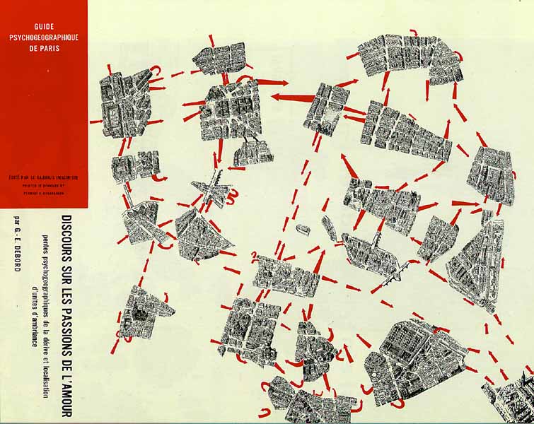 |
| from http://imaginarymuseum.org/LPG/debordpsychogeo.jpg |
Ciaran's presentation
Coincidence time -I emailed the link to CM's talk to somebody this morning. Must be in the air.
ReplyDeleteI can't remember where I saw it posted up... just one of those things that often fly by. It just reminded me of Guy Debord's famous map, where he ripped up the plkan of Paris along the Boulevards that were difficult to cross, creating islands communicating along proscribed routes "....The map of Paris has been cut up in different areas that are experienced by some people as distinct unties (neighbourhoods). The mentally felt distance between these areas are visualized by spreading out the pieces of the cut up map. By wandering, letting onself float or drift (dériver is the French word used) each person can discover his or her own ambient unities of a specific city. The red arrows indicate the most frequent used crossings between the islands of the urban archipel (seperated by flows of motorized traffic)..."
ReplyDeleteMackels description of the fractured city landscape in belfast is upsetting.
ReplyDelete