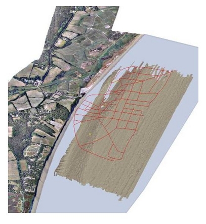
How a port, which once rivaled London in size, could disappear beneath the sea and almost from memory provides a salutary lesson in these days of rising sea levels
"...Present day Dunwich is a village 14 miles south of Lowestoft in Suffolk, but it was once a thriving port – similar in size to 14th Century London. Extreme storms forced coastal erosion and flooding that have almost completely wiped out this once prosperous town over the past seven centuries. This process began in 1286 when a huge storm swept much of the settlement into the sea and silted up the Dunwich River. This storm was followed by a succession of others that silted up the harbour and squeezed the economic life out of the town, leading to its eventual demise as a major international port in the 15th Century. It now lies collapsed and in ruins in a watery grave, three to 10 metres below the surface of the sea, just off the present coastline...." http://www.southampton.ac.uk/mediacentre/news/2013/may/13_80.shtml
From http://www.dunwich.org.uk/ ... click on links for more


Images of All Saints Church courtesy of the J. C. Docwra Collection and the EA Shoreline Management Group.


No comments:
Post a Comment